The Florida Seminoles
Lesson Plans
SS.4.A.3.8: Explain how the Seminole tribe formed and the purpose for their migration.
Resource:

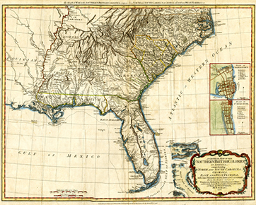
Romans’ General Map of the Southern British Colonies (ca. 1776)
(Slide One)
This lesson plan describes the origins of the Seminoles and the reasons for their migration into Florida.
(Slide Two)
The resource for this lesson plan is a British map from the 1770s created by the English surveyor Bernard Romans.
The map shows the location of English colonies on the Atlantic Coast (Slide Three). The map also has great detail on the Creek and Cherokee nations (Slide Four).
Europeans and Africans reached the land that is now known as the southeast United States in the early 1500s. With them they brought diseases, plants, and animals that changed the lives of Native Americans forever.
By the early 1600s, the impacts of disease and warfare changed Native American communities. Tribes had to find new places to live and joined together in order to survive.
(Slide Five)
One of the new groups that formed was known as the Creeks. English colonists first used the term Creeks to describe Native Americans who lived on rivers in eastern Georgia.
Later on, the English used the term to refer to Native Americans who lived throughout Alabama and Georgia.
(Slide Six)
The Creeks spoke the Muscogee language. The Muscogee language contained many regional dialects.
The Creek territory extended from the Coosa/Tallapoosa Rivers in Alabama (Slide Seven), to the Flint/Chattahoochee Rivers in Georgia (Slide Eight), and about as far south as the modern Florida-Georgia border.
(Slide Nine)
By the mid-1700s, some Creeks known as Lower Creeks started migrating into Florida. They settled in North and Central Florida (Slide Ten).
The blue triangles represent a few of the Seminole towns. The major Seminole towns were near modern-day Tallahassee, Lake Miccosukee in Leon County, the Suwannee River, and Gainesville.
Because these people moved away from the rest of the Creeks, they became known as simanolis (Slide Eleven), meaning “those who camp at a distance” in the Muscogee language. To the Spanish they were known as cimarrons, or “runaways.”
The two terms merged—Simanolis and Cimarrons—and became “Seminole” in the English language.
The Seminoles separated from the Creeks for economic and political reasons.
Economically, they wanted to be closer to land and game in Florida. They also moved to Florida to trade with the Spanish and the British. Over time, the Seminoles became politically independent from the Creeks.
(Slide Twelve)
Joining the Seminoles in Florida were escaped slaves. Called “Black Seminoles” by historians, these people came to Florida in search of freedom.
The blue triangles represent a few of the known Black Seminole villages, including Suwannee Old Town, Piliklakaha northeast of Tampa, and Angola near Sarasota.
(Slide Thirteen)
The largest Seminole town was called Cuscowilla. It was located near modern-day Gainesville. The Seminoles who lived at Cuscowilla herded thousands of head of cattle.
In addition to herding cattle, Seminoles planted fields of corn, beans, and squash.
(Slide Fourteen)
By the year 1800, Seminole and Black Seminole towns extended from the area west of present-day Tallahassee in the Florida Panhandle, to near St. Augustine on the east coast, and as far south as the Caloosahatchee River near today’s Fort Myers.

 Listen: The Latin Program